Note: We're catching up on time in Canada. This post was entered on 08/27. It's the final piece of the Canadian story.
We planned a lot of touring for today. The Parks Canada Mountain Guide was a great help. We're going to Maligne Canyon, Medicine Lake, Maligne Lake, Sunwapta Falls, Athabasca Falls, and Mount Edith Cavell.
First, we drove to Jasper for breakfast at Palisades Restaurant. The meal was reasonably priced and quite good.
We then took Maligne Road southeast out of Jasper. Maligne Canyon was our first stop. Some places are so deep you can't see bottom.

Maligne Canyon

Maligne Canyon
Medicine Lake is beautiful and mysterious. Water disappears into a crevice under the lake and travels 17 kilometers (10.56 miles) underground before exiting into a river.

Medicine Lake

Medicine Lake - mystery
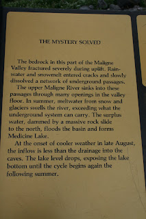
Medicine Lake - explained

Medicine Lake - actions
We saw this field of flowers along the road between Medicine Lake and Maligne Lake. We also saw caribou and mule deer, but didn't get pictures.

Lake Maligne
We drove back to Jasper and south onto the Icefields Parkway for the rest of our exploration.
We saw a convoy of three VW campers at a scenic overlook site. The camping van below is included for Dorrie & Karen Andermills. They had one and loved it.
The views along the parkway were many and awesome. Here are a few.

Mount Fryatt

Mount Kerkeslin
Sunwapta Falls had a complex flow path. We walked over and around the chasm. Carol saw a brown bear cross the path during our wandering.

Sunwapta Falls - entrance

Sunwapta Falls - exit

Sunwapta Falls - channel
Athabasca Falls had many different levels to walk around. It rained part of the time. Fortunately, we had our trusty ponchos.

Athabasca Falls - entrance

It's a long walk down to a lower level of Athabasca Falls.

Carol views the Athabasca Falls channel

Athabasca Falls channel
The last stop of the day was at Mount Edith Cavell. We drove a road with steep climbs and many switch-backs. We then hiked the 2 mile (round trip) trail to Cavell Lake and Angel Glacier. It rained and it was cold.

Cavell Lake from the trail

Cavell Lake from the trail

Angel Glacier

There's an ice cave under the glacier. We decided not to hike there.

The trail back shows the moraine left by the glacier.
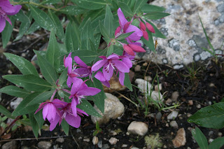
Delicate flowers survive amid ice and stone.
We headed home for a hot dog supper. Then we went to Jasper to use the computer and to shop a little.
Map Tracks
None for today
 Mt. Baker background
 The climb into the clouds
  Picture Lake reflects Mt. Shuksan
 Artist Point - 5,140ft
 It's August 10th and drifts are still over 10ft high.
 The road had some serious switchbacks
 A peaceful view as we headed home


 The Natural Bridge story


