Wednesday, August 18, 2010

Day 32 - (08/19) La Push, WA ... Day 1

This was another morning with clouds hanging low into the mountain tops. We hooked up and were on the road by 10am.

The drive to La Push was uneventful and quite pretty. The clouds cleared and the sun brightened views of Crescent Lake, the forests and the mountains along the way.

We checked in at Lonesome Creek RV Park at noon. We’re staying on the ocean at Beach #1 tonight. Beach #2 and Beach #3 are short distances south of us; Rialto Beach is just north.

Our first real outing today was to Beach #3 (creative beach names, huh?). The trail to the beach led us 2.8 miles (round trip) through the forest. This hike was dramatically different than the one at Hurricane Ridge ... it was level most of the way (hurray!), cool and damp.

Beginning the trail to Beach #3

Beach #3 as we emerge from the rain forest

Sea Stacks at Beach #3

This father, son and friend start a three-day camping adventure

We hiked out with Gary & Jane Hill from Kentucky.

La Push is a quiet little fishing village and tribal headquarters for the Quileute Indians.

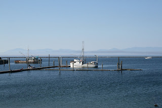
La Push marina

Quileute Indian center

Quileute Indian school

Our Beach

View of drift logs in front of the trailer

Root base of the spruce tree trunk shown above & below

It's a biggie! (Note: the shiny spot on the right is our trailer.)

Looking down the beach - south of the trailer

Looking up the beach at sunset - north from the trailer

Map Tracks

Start: Shadow Mountain RV Park

West on US-101 to Washington 110

West on Washington 110 to La Push, Washington

End: 57 miles @ La Push, Washington

Tuesday, August 17, 2010

Day 31 – (08/18) Port Angeles, WA ... Day 3

The morning started with clouds hanging low into the mountain tops. The temperature was in the mid-50s.

We stopped at Granny’s Café for breakfast. Granny’s is a delightful little place on US-101 a few miles east of the campground. There were six tables and a counter. The place was full (no surprise), the service was excellent and the meal was quite good home cooking.

This is to be a day of hiking and touring parts of the Olympic National Park. We started with a drive to the Hurricane Ridge Visitor Center. The 17 mile trip gave us a real kick-start for the day. The clouds cleared, the road was really curvy and the mountain views were breathtaking. This trip really should have been made in a Miata.

There are lots of Olympic Mountains

Here's an eastern view of some from the visitor center

Here's a western view of some from the visitor center

The western view ... a bit closer, with Mt. Olympus in the center

We drove 1 ½ miles beyond the visitor center on an even curvier, narrow road to the start of the Hurricane Trail. It’s 3.2 miles (round trip) and climbs 700 ft in elevation to nearly 6,000 ft..

Carol's ready to head way up there

But, she finds a "way down there" on the way up

Steve & Carol (retired teachers from CT) were hiking partners

The smiles come when you get close to the top

A look back at the trail we've travelled

You can see Port Angeles from the summit

A view of the top of the ridge

This is the end of the trail

Oops, Dick must have backed up too much.

The hike was pretty tiring. Carol wasn’t feeling well, so we went back to the campground for rest and a relaxing pasta dinner.

We’re heading to the ocean tomorrow. We’ll be staying in La Push on the Quileute Indian Reservation.

Map Tracks

Start: Shadow Mountain RV ParkEast on US-101 to Port Angeles, Washington
South into Olympic National Park to Hurricane Ridge
Return
End: 73 miles @ Shadow Mountain RV Park

Day 30 - (08/17) Port Angeles, WA ... Day 2

We stayed at the Shadow Mountain RV Park and did housekeeping chores today.
Dick took care of bills and catching up on blog updates. Carol did laundry and went into Port Angeles.


Map Tracks
None today

Day 29 - (08/16) Port Angeles, WA ... Day 1

Today was our second trip to Port Angeles in three days. The drive was short and uneventful. We did notice a significant difference between the towns of Port Townsend and Port Angeles. Though both are known for their ferry services, Port Townsend is smaller and much more attractive.

We’re staying at the Shadow Mountain RV Park. It’s on US-101, in the mountains and about 15 miles west of Port Angeles. We’re on the top tier of sites on a mountainside. This is a very nice campground.


After set up, we took a scenic drive to Cape Flattery. The trip follows Washington 112 along the Straight of Juan De Fuca. The 150 mile round trip took nearly six hours. The views were phenomenal; the road was narrow with lots of steep hills and tight switchbacks. The trip was special because we got to the northwestern-most point in the contiguous US.

The Road

The road was like driving through a tunnel of trees.

Pillar Point

Pillar Point & Straight of Juan De Luca


Sekiu

Another fishing village


Neah Bay
Neah Bay and Cape Flattery are on the Makah Indian Reservation. Fishing is a big business here.

Lots of fishing boats at Neah Bay


Cape Flattery

We made it to the end of Washington 112 and to the trail to the cape.

Carol's ready to start the trail.

Trail is 1.5 miles through the forest.

Marine layer shrouds bay at the cape.

Bay at the cape ... with caves.

At the northwestern-most point of the contiguous US

Bay at the cape.

Now, here's a strange shaped tree.

The Return

We took a faster route home. Washington 112 east, then Washington 113 south to US-101, and east on US-101 past Lake Crescent.

Crescent Lake is 600' deep

Map Tracks
Start: Port Townsend, Washington
West on Washington 20 to US-101
West on US-101 to Shadow Mountain RV Park
End: 66 miles @ Port Angeles, Washington

Day 28 - (08/15) Port Townsend, WA

We had a leisurely start today. It’s a short trip to Port Townsend. Since we have no reservations at our target state campground, it seemed prudent to let previous campers pack up and leave.


This friendly fellow stopped traffic as we headed north.


US-101 has many peaceful views like this.


We got a very nice site at Old Fort Washington State Park. We’re 4 miles west of Port Townsend. Unlike the Hoodsport park (which was located right on the highway), this park is deep in the forest. There'll be no highway noises tonight.


We toured Port Townsend and Fort Worden State Park in the afternoon.

Port Townsend

This town has worked hard for a rebirth and it's doing quite well. The downtown was alive with shops, restaurants, hotels, business and ... people. Victorian architecture abounds and is well maintained. The ferry to Whidbey Island is very popular.


Downtown


Whidbey Island Ferry


They're proud of their waterfront


Lots of docks and warehouses


They play cool watersports, too

The Bishop Victorian Hotel - downtown

Fort Worden

The fort was active from 1904 into the 1950s. It was part of a three fort observation triangle that protected entry to Puget Sound. The state has put the remaining 100+ buildings to work for conferences, meetings, exhibits, tours and vacation rentals.


We toured the commanding officer's quarters. The period furnishings, life stories and presentation were exceptional.


The Point Wilson Lighthouse still operates, but not as originally built.


Point Wilson Lighthouse


Day's End


After dinner in the trailer, we walked down to the beach.


Carol by Port Townsend Bay

Did you know?

These are some of the tidbits from life in 1905 we picked up at Fort Worden.

  • There were only 8,000 cars in the US and 144 miles of paved roads.
  • The average wage in the US was 22 cents per hour.
  • 90% of all US doctors had no college education.
  • The population of Las Vegas, NV was 30.
  • About 95% of all births in the US took place at home.

Map Tracks
Start: Hoodsport, Washington
North on US-101 to Washington 20
East on Washington 20 to Old Fort Townsend State Park
End: 57 miles @ Port Townsend, Washington